Day 4
We woke late after a lovely restful sleep, and unfortunately no encounter with the ghosts, to the smells of a multi-course breakfast. We were served a tomato, cheese and onion souffle, several different home baked breads and muffins with lemon curd, a lovely homemade berry cobbler with sweet cream and coffee. Everything was delicious.
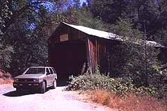
We packed the Pathfinder and headed for the next form of mining operation -- the hydraulic mine. We passed several small, lovely Gold Rush towns with lots of buildings, long uninhabited. We stopped at a road side park with paths that lead down to the Yuba River and lovely cool swimming holes. As early as 11:00 in the morning, lots of people and their dogs were taking refreshing dips to cool off from the day's early heat. We stopped next at the Bridgeport covered bridge and drove through the small park and campground there. The Bridge, which the current highway bypassed, was built in 1862 as part of a toll road from Marysville to Virginia City by way of Henness Pass.
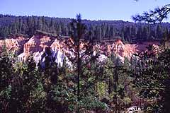
We headed back up Highway 49, past the town of San Juan and out Tyler Foote Road toward the Malakoff Diggins State Park. While the Malakoff Diggins, which resembles a small grand canyon with pleated hillsides of multicolored rock, is beautiful in its own way, it stands as a monument to the avarice that was part and parcel of the Gold Rush. The Malacoff Diggins was responsible for one of the nation's first environmental disasters and thus the development of one of our first environmental-protection measures.
One of the 3 principal forms of mining used in the Gold Rush was Hydraulic Mining. During the first couple of years of the Gold Rush most of the easy to find gold was depleted. But the deep, stratified sediments overlying bedrock in certain regions were found to be full of gold. Not nuggets but fine particles, almost dust, that was difficult to extract by conventional mining methods. It didn't take long for resourceful miners to devise a method for getting at this gold and in 1852 hydraulic mining was invented.
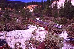
Water from high mountain lakes and rivers was funneled through a series of canals and pipes which decreased in size as the water traveled to the mine site. By the time the water reached the mines it was under intense pressure and was sprayed through Monitors --large nozzles -- for hundreds of feet at the mountain sides to wash away the top soil and expose the bedrock underneath. The "tailings" -- muddy water, rock and whatever else washed down -- were run through a series of sluice boxes allowing the gold to settle to the bottom which was then collected.
Unfortunately this was the most environmentally destructive form of mining and turned the beautiful countryside into a scene of devastation. Tons of silt and debris clogged the streams and rivers causing widespread flooding downstream. At one point runoff from the Malakoff Diggins raised the level of the Yuba River near Marysville, 70 feet higher than the level of the town, flooding it completely. This form of mining went on until 1884 when Judge Lorenzo Sawyer placed a permanent injunction against dumping tailings into the state waterways, effectively banning hydraulic mining. This kind of mining was as dangerous to the miners as it was to the environment. Sometimes whole hillsides would give way, burying the miners in the debris.
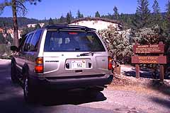
The Malakoff Diggins is one of the best examples of hydraulic mining. This operation is now a State Park and can be reached by road. The last 8 miles of this road is dirt, so it is a good idea to drive it in a 4-wheel-drive vehicle like the Nissan Pathfinder. Regardless, drive it carefully. The park includes the restored town of North Bloomfield which serviced the Malakoff Diggins. It has a small but interesting museum and about a dozen restored historical buildings. The park rangers give tours and lectures and there is a 20-minute movie to watch.
Heading west out of town you will come upon two viewing sites. Stop at the first one to get a good overview of the Diggins from the top of the ridge. Then continue on to the second viewing site. After parking the car, walk down the hill into one of the mine pits. Standing next a rusting Monitor on valley floor you can almost hear the roar as they blast away at the hillsides. The sounds of hundreds of miners laboring away their lives in this mud pit is nearly audible. Visiting the Malakoff Diggins affected us deeply as it is a very sad place. By the time hydraulic mining was stopped, more than $350 million worth of gold was collected from the Malakoff Diggins. It is believed that there is still more gold there than was never taken out.
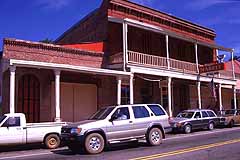
From the Malakoff Diggins, we headed further up Highway 49 passing the towns of Downieville and Sierra City. All of the towns in this area are lovely and each has several B-and-Bs and artisan shops.
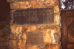
We backtracked along Highway 49 to the town of Grass Valley and followed the signs leading to the Empire Mine State Park. This is a fascinating area, too important to be missed.
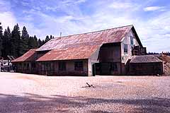
The Empire Mine was the largest traditional (hard rock) mine in the Gold Rush Country. At its deepest, the mine shafts reached down over 11,000 feet -- a full mile in vertical depth. The park museum has displays describing the history of the mine. Don't miss the three-dimensional model that depicts the mine shafts. The model resides in the very room in which it was built in 1938. It was developed as a mapping tool for the mine engineers. The mine is an organized spaghetti bowl of hundreds of shafts. It is unbelievable that nobody ever got lost.
It is an absolutely amazing fact that during the 106 years of operation -- 1850 to 1956 -- that in those 500 miles of shafts only four people were killed.
From the museum, we took a self-guided tour of the above-ground facilities. While there are ranger-guided programs, the self-guided tour is well laid out and the documentation gives an excellent view of the mine's history. The buildings are well preserved and give a clear view of what the operation was like. All the original shafts still exist but a tour of them is not currently available. However, funds are being raised to install the necessary trams to take visitors underground. Currently one can only walk down to view the first 100 feet of the main shaft.
After visiting the mine, we headed back to Highway 49 then to Highway 80 and a quick 1-1/2 hour drive back to the Sacramento Airport. Even at rush hour this was a quick and easy drive.
Last Thoughts
The California Gold Rush region is fascinating, filled with important American history and loaded with wonderful places to stay, shop and eat. Gather the kids or a special someone and jump in a Nissan Pathfinder and find your way to this region. Unless you spend at least a week in the area, there is no way to see it all. So come often and learn about this epic story. You'll enjoy it.


